

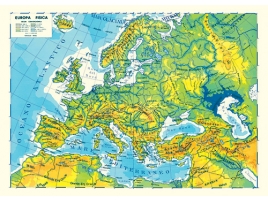


To create a geographical map, different strategies are used, some aimed at establishing the real key points on the map, others at understanding their distance, the conformation of the land, the type of mountains and lakes present naturally.
First of all it is necessary to carry out the triangulation of the terrain which is based on the geometric concept that by knowing one side and two angles of a triangle, it is possible to establish all the other parameters.
Put simply, places that are rather close and not aligned are decided, such as the bell tower of a church or the top of a mountain, in a ternary relationship; subsequently we understand the distance between them which will become the geodetic segment and will be reported to scale on the geographical map.
From here, the game is the same and we proceed to create triangulation networks, representing all the space available. Another fundamental procedure is the topographic survey, aimed at understanding the conformation of the territory, the altitude of the mountain peaks, the depth of the rivers and lakes, as well as their course. The presence of artificial elements such as roads, bridges and underpasses is also established.

Once upon a time, topographic surveying was carried out on site, on the ground; today technological tools are used that facilitate and speed up results, such as remote sensing and aerial photogrammetry.
The latter exploits the photographic trail of multiple rapid and super close-up shots with which the representation of three-dimensional images is obtained. The photographs are taken thanks to aircraft flying over the area in question. The superimposable images are then put into relation thanks to a particular instrument, called a stereoscope. In this way you obtain the virtual representation of the geographical map in 3D.
Remote sensing, on the other hand, uses devices present in satellites that float hundreds of kilometers above the ground. Here infrared, visible or ultraviolet images, electromagnetic radiation and other signals are captured and then sent to terrestrial bases which transform them into photographs.
These methods are effective not only for understanding the depth of seas and lakes, but also the type of land to be cultivated and methods for predicting natural disasters such as earthquakes and floods.
-

-

Physical and political school map
Physical and political school map printedon both sides Size: cm 100 x 14...
-

Antique map of America
Color reproduction of an antique map of America by an original of 1805. Siz...
-

Antique map of Asia
Color reproduction of an ancient map of Asia from an original of 1788. ...